Himalayan Encounters
Exhibition Venues & Dates
40 Max Mueller Marg
Inauguration: 21 April
Inauguration: 1 May
Inauguration: 12 May
You can download the PDF version of catalogue from here
When, a decade back, I was invited by Prof. Hermann Kreutzmann of Free University, Berlin to speak on Himalayan Explorations and who took me to Alpines Museum at Munich to speak on Pundit Nain Singh Rawat, I was thinking about listening and knowing more about Alexander von Humboldt and Carl Ritter and contributions of the Schlagintweit brothers to Indian geography, topographic surveys and Himalayan studies. But it was more than that. It was really a new beginning for me and Pahar.
Madam Stephanie Kleidt, who curated, designed and implemented the exhibition, very kindly arranged a meeting in the ‘Staatliche Graphische Sammlung’ in Munich, where many drawings were kept in high care. I may be among very few or first fortunate Indians, who saw the drawings, sketches and paintings of Nainital and surrounding areas of Kumaon, higher Himalayan scenes and sacred places from the mid-nineteenth century in high quality and original great detail. Though I have seen the Schlagintweit volumes at Survey of India in Dehradun and Sven Hedin Foundation in Stockholm and had the sense of their larger Himalayan documentation.
Immediately a dream started twinkling about how we can do an exhibition of some of these images in our country and present the connection which happened more than one and half century ago. It was really a difficult dream. Continuous involvement and initiations of Hermann and Stephanie made it possible and we are in the first phase organising the exhibitions with opening lectures at three places- India International Centre, Delhi; Doon Library and Research Centre, Dehradun and CRST College/ RST Uttarakhand Academy of Administration, Nainital.
We from Pahar express sincere thanks to ‘Alpines Museum’, the ‘Staatliche Graphische Sammlung Muenchen’, the Bavarian State Library, members of the Schlagintweit family and the institutions-organisations-sponsors-individuals, who contributed towards hosting the exhibitions in India. We thank Prof. Hermann Kreutzmann, Madam Stephanie Kleidt, Dr. Johannes Erichsen, Stefan Ritter and others in these institutions for such a deep interest and regular support for this exhibition in India.
We are also grateful to I.I.C. and its president Mr. Shyam Sharan, (and others at IIC); German Embassy, Ambassador Mr. Philipp Ackermann, Delhi; D.L.R.C., its Chairman Prof. B.K. Joshi, Hon. Director, Mr. N. Ravi Shanker, Mr. N.S. Napalchyal, Mr. C.S. Tiwari and Mr. Nicholas Hoffland, Mr. Lokesh Ohri (INTACH), Mr. Sanjeev Chopra (VoW), Dehradun; Mr. B.P. Pandey, D.G., RSTUAA, Mr. Anup Sah, Manager/ Mr. Manoj Pande, Principal, CRST College, Nainital. Our sincere thanks to UCOST, Dr. D. Pant and Deptt. of Tourism, Mr. D. Garbyal, Govt of Uttarakhand for supporting the exhibition and associated publications.
Pahar team (Mr. C. Dangi, dealing with all issues regarding exhibition in Delhi, Mr. G. Pande, Mr. A. Upadhyay, Mr. P. Bisht and Mr. H. Pathak) is working behind. Thanks to them and also to Mr. S. Joshi and Smt. Usha Kashyap, who did a lot in a little given time in printing the catalogue and the calendar.
Shekhar Pathak
for Pahar Team
21 April 2026
To present the Schlagintweit paintings for the first time in India is due to many coincidences and initiatives in Germany and India. The Schlagintweit brothers and their Indian collaborators have proven a fruitful cooperation during their collaboration, an early example of Indo-German scientific cooperation in the fields of geology, geography and landscape studies. The idea for the Indian exhibition was born in September 2015 when Prof. Shekhar Pathak visited Munich during a symposium highlighting the Schlagintweit expeditions in the framework of a major display of their collected artefacts, masks, ethnographic items, maps, measurements and recordings. The central theme was the display of the Schlagintweit paintings in the context of their expeditions. The paintings had been donated by heirs from the Schlagintweit family to the Alpines Museum in Munich.
On this very occasion Shekhar Pathak represented Indian scholarship during the symposium and was interested to see more of the Schlagintweit paintings and especially the ones from the archives. The art historian Stephanie Kleidt, the mastermind behind curating, designing and implementing the exhibition, arranged a meeting in the ‘Staatliche Graphische Sammlung’ in Munich where many surprise findings were held in stock. For the first time, he saw drawings of Nainital and surrounding areas of Kumaon from the mid-nineteenth century in high quality and great detail. Immediately the idea was conceived that these paintings should be shown in India to make an interested public and academic institutions aware of the wealth of information that is contained in these images made 170 years ago.
It took more than a decade to implement this idea with exhibitions in New Delhi, Dehradun and Nainital, and hopefully many other places. The efforts of the editors of this volume resulted in small grants from the Free University Berlin, the Ernst-Reuter-Gesellschaft, Berlin, and donations from Schlagintweit family members. All these are gratefully acknowledged. Other institutions and persons were instrumental in implementing the project. It required diplomatic skills and professional determination by all participants from academia and practice, from art history, history and geography, from independent commitment of retirees and people- and student-oriented associations in civil society and institutions from higher learning to convince the keepers and owners of the ‘Schlagintweit paintings- the ‘Alpines’, the ‘Staatliche Graphische Sammlung Muenchen’, the Bavarian State Library and members of the Schlagintweit family – as well as the institutions and organisations hosting the exhibitions in India. The whole team is grateful to all donors and sponsors, hosts and supporters and all invisible activists and professionals contributing in the preparation of the Schlagintweit paintings exhibition project in India.
Dr. Johannes Erichsen, Stephanie Kleidt, M.A., Munich
Prof. Hermann Kreutzmann, Berlin
About the Exhibition
Hidden Views of the Himalayan Belt — 170 Years After
Sketching the Himalayas 170 years ago was an exploratory endeavour strongly embedded in its contemporary thinking, knowledge-generation, geographical curiosity and geopolitical interests. The mid-nineteenth century is characterised by advancements in spatial measurements, geographical surveying, technology development and atmospheric recording instruments. Geographical exploration and scientific advancement were a cosmopolitan affair and the Schlagintweit expeditions are ample proof of such a quest for augmenting existing knowledge. Their endeavour was embedded in the accumulated knowledge from earlier travelogues and manuscripts, historical narratives and tales. The cosmopolitan approach was not limited to knowledge-generation. The expedition teams themselves were composed of people from various backgrounds and origin, the sponsors and clients were not limited to one or the other country.
The innovative techniques of capturing landscapes and environmental features, recording archaeological artefacts and cultural sights had been pencil sketches and water colours, while photography was still in its early stages. The Schlagintweit images, now displayed for the first time in India since their thematic conception 170 years ago, fall into the category of parallel structures of recording, i.e., sketching with pencils, drawing with oil and water colours, and photographing and hand colouring. Their interest in geographical artefacts and features is reflected in the themes of the exhibition. The landscape paintings are covering the whole range of the Himalayan belt from Assam to Baltistan and Ladakh, from the Himalayan rimlands and the Khasi Hills to the Trans-Himalaya, Tibet and Bhutan.
For the foreign explorers new and never seen worlds were opened to their eyes; places of worship were significant locations that attracted numerous pilgrims and visitors whom they admired and met along their routes. The road conditions are reflected in conventional travel of their time, on boats, horseback and on foot, river passages and bridges attracted their attention; the scattered mountain settlements appear as hamlets and isolated dwellings with hitherto unseen construction principles and building techniques in challenging environments.
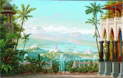
The paintings remember us of a Himalayan world (Fig. 1) that has left our perception as the dynamic change in infrastructure, settlement patterns, agricultural technologies and immigration of lowlanders into mountain communities has covered and/or extinguished previous livelihood patterns, habitats and ecological environments. The Schlagintweit expeditions took place just before the Indian Rebellion of 1857 which marks the turning point from colonial East India Company intrusions and occupations to the imperial establishment and domination of British India.
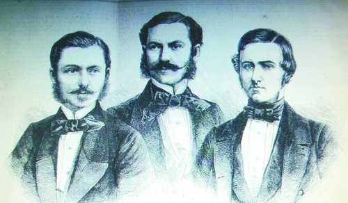
The selection of paintings for this exhibition was guided by our desire to show vanishing worlds that might act as a reminder how fast the pace of change has been and what has been lost on its course. Some artefacts and landscape appearances have survived while other dwellings and natural phenomena are lost for ever. The Schlagintweit brothers (Fig. 2) were inspired by a view of natural features and cultural artefacts that was embedded in their German upbringing and training as well as inspired by their professional mountain experience as geographers and geologists in the European Alps.
The guiding questions of their time were about the formation of the highest mountain systems on Earth and about clarifying and fixing the locations of known and hitherto unknown places in an exact manner so that reliable maps could be constructed and expand the world view. Scientific challenges were to grasp the monsoonal weather regimes, its influence on agricultural practices, the conditions for travelling and to a lesser degree an enhanced knowledge about the life of mountain dwellers and communities.
The application of state-of-the art techniques in recording and documenting was linked to the overall aim of better understanding potentialities of world regions, accessibility conditions and opportunities for exploitation. With their drawings, recordings and writings they significantly contributed to Indian geography and initiated further Himalayan Studies. Somehow their expedition and the generated results triggered further enquiries, provided fundamental insights for mountain studies and inspired their successors. Nevertheless, they were part of their contemporary world of science, influenced by their teachers and guided by their Indian companions, map-makers, information-gatherers, guides and translators.
The success of any expedition was strongly depending on what the Schlagintweit brothers called their ‘establishment’, i.e., the whole team of supporters, from guide to translator, from surveyor to map-maker, from trader to messenger, from purchasing agent to kitchen staff, from horsemen to load carrier, and many others completed the team that sometimes consisted of several hundred men. Focusing on the grandeur of the Himalaya mountains, well-known experts from Uttarakhand opened their eyes for the beauty of landscapes and relevant issues along their routes. Some members of the ‘establishment’ were trained and motivated to start their own careers as informants, surveyors, guides, translators and/or spies afterwards.
The Historical Context of Geographical Exploration
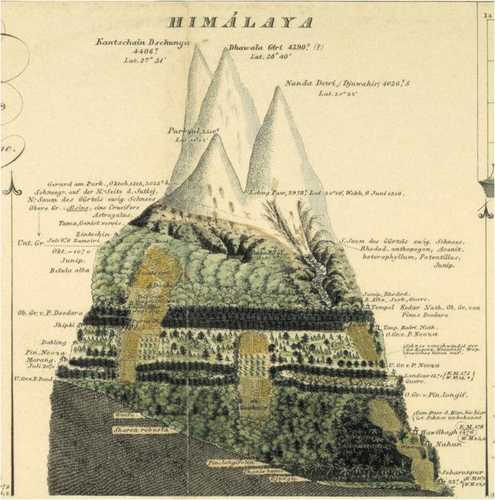
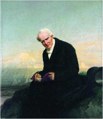
The pioneering efforts of comparative and systematic mountain studies were fostered by its doyen Alexander von Humboldt. He himself had been an active field researcher in cosmopolitan teams operating in Latin America and Europe. Alexander von Humboldt became renowned for his mountain profiles (Fig. 3) that became comprehensive diagrams for grasping its complexities. The ecological layers distinguish between the densely populated and cultivated foothills and rimlands, in the belt above other environments such as forests and pastures appear and form the operating centre of mountain dwellers, higher up treeless and glaciated regions at the upper limit form the limit of the ecumene.
To complement Alexander von Humboldt’s empirical and theoretical studies of the ‘Kosmos’, Heinrich Berghaus published diagrams and maps in an atlas volume, which contains comparative diagrams for the Latin American Andes, the European Alps and the Pyrenees, for the Himalayan region he relied on the works of British botanists.1 This was the state-of-the art compendium on mountain studies before the Schlagintweit brothers were commissioned to set-off for India and to enhance the geographical knowledge about High Asia.
The comparative diagrams were published in the map compendium by Heinrich Berghaus between 1845 and 1848; a recent reproduction is found in Heinrich Berghaus (2004). ‘Physikalischer Atlas. Frakfurt’/Main: Eichborn, pp. 100-101.
Reflecting on the handling of knowledge, it is important to note that from an academic point of view the work of Alexander von Humboldt and the Schlagintweit brothers provided the foundation for what was to be subsequently called comparative high mountain research.1 Before their endeavours there was a rather limited library of manuscripts and narratives in foreign languages as well as some travelogues from earlier explorers available spanning several centuries since Marco Polo, Ibn Battuta and Benedict Goes. No systematic and in the best sense empirical fieldwork-oriented material was available; most researchers in the ‘oriental sciences’ relied on second-hand material laid down in nineteenth century archives.
Alexander von Humboldt (1817); Hermann, Adolphe and Robert von Schlagintweit (1861–1866); Carl Troll (1975).
Alexander von Humboldt’s systematic empirical approach inspired his theoretical reasoning and attempt to synthesise knowledge, his ultimate goal was to find a theoretically sound geological or convincing volcanic explanation for the formation of mountains (Fig. 4). Their complex structures and manifold variations demanded sound recordings of geographic properties in terms of climate and weather conditions, geology and geomorphology, mineralogy, soil composition and vegetation cover.
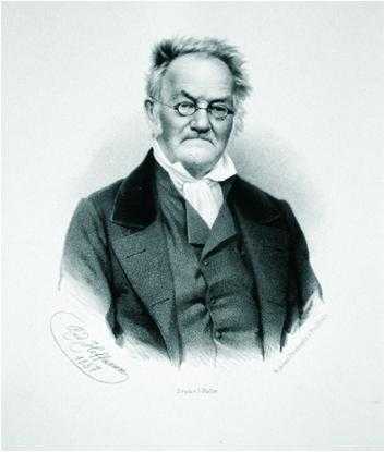
The Berlin school of geography was complemented by the efforts of Carl Ritter, the great collector of historical and geographical manuscripts (Fig. 5). Carl Ritter augmented Humboldt’s conceptual approaches with extensive compilations in Berlin; he collected all literature and maps that were accessible to him, compiled multi-volume tomes of geographical descriptions and cooperated with leading cartographers to produce state-of-the-art maps.1 Still the access to reliable maps (Fig. 6) was rather limited prior to the Schlagintweit expeditions.
The Schlagintweit expeditions were part of a movement to gather a wealth of topographical information about the extent of empires and principalities, the topographic location and altitude of cities, oases towns, trading posts, mountain peaks, river valleys, the distribution of ethnic groups and languages etc. As Felix Driver summarised: “… these collections included soil and water samples, wood specimens, rocks, seeds, plants, reptiles and other animals, paper, textiles, religious artefacts and sacred texts. Indeed, if they could have done, they would surely have bottled the very air of India!”2 Often, the collectors were overwhelmed by the extent of their material and had only a few clues and theories what to do with the data. They compiled inventories, collected ethnographic specimen, produced water colour drawings, early photographs, topographical sketches and maps. The quality of their activities was strongly linked to the accuracy of recording topographical information, glossaries of vernacular terms and proper descriptions of objects.
The process of structuring the material was leading to what would becomegeographical landscape studies, in which definitions and their properties were part of a set of mutually understood standardised categories. Earlier on the densely settled lowland regions were the prime target while mountain areas were treated as thoroughfares for caravans, traders and pilgrims. People living there were marginal communities in the periphery. At the same time, their expertise and skills were required for crossing mountains and connecting empires.
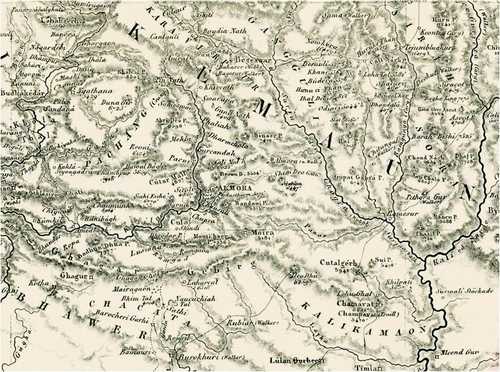
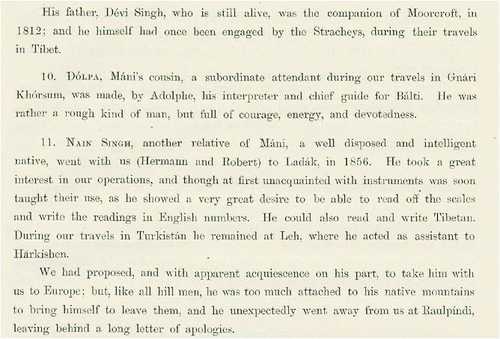
In the context of the Himalayas the pioneering work of the Schlagintweit brothers led to thegeological distinction of the Karakoram as a separate mountain range from the Himalayas as hinted by William Moorcroft before.3 Soon the ‘Indian Caucasus’ would become the Hindukush Mountains. The filling of ‘blank spots’ became an obsession.4 The Schlagintweit expeditions were setting the stage for a great effort in which their counterparts from Uttarakhand – among the ‘observers’ was Harkishen, among the ‘collectors’ were Luri, Joha, and Mohon Singh from Kumaon, and among the ‘interpreters’ were Mani Singh, Dolpa Singh and Nain Singh Rawat – provided their logistical and linguistic expertise, received training in various kinds of measurement and research practices.
1. Carl Ritter (1832, 1834); see Carl Zimmermann (1841) for the compiled maps.
2. Felix Driver (2018) : 442; see for the ‘zeitgeist’ of this exploratory effort Brescius (2018) and Brescius, Kaiser and Kleidt (2015).
3. William Moorcroft and George Trebeck (1841).
4. See Hermann Kreutzmann (2015: 102-112; 2017 : 63-68).
A Collaborative Effort in the 19th Century
The Schlagintweit expeditions had prepared the stage for further systematic enquiries and exploration within British India and beyond. The impact and outcomes would be felt and appreciated in the decades to come. The British authorities realised the importance of ethnographic, geographical and geologic knowledge gathering, the political value of background information and intelligence reports from places beyond their immediate realm in order to prevent intrusions and surprises on the borders of their sphere of influence and to identify commercial opportunities in trade and commodity exchange.
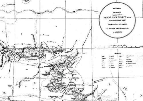
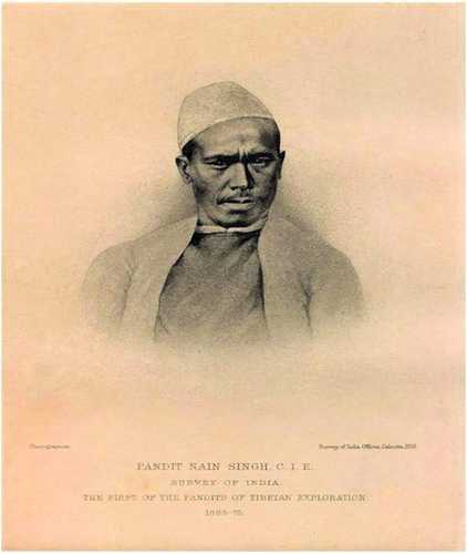
When Thomas Montgomerie set up his group of ‘native explorers’ after the fatal murder of Adolph Schlagintweit in Kashgar in 1857 and the acceleration of the Great Game it was not surprising that experienced and skilled people such as Nain Singh Rawat would play a central role in route exploration and providing topographical information for the compilation of gazetteers.
From the British intelligence and cartography centre in Dehra Dun Nain Singh Rawat, being a Kumaoni schoolteacher, and Mani Singh, who had gained expertise in surveying when employed by the Schlagintweit brothers, were sent to explore routes, landscapes and communities in the Himalayas and Tibet. Their exploration was directed towards Tibet, and their return journey took two and half years after they had left Dehra Dun in March 1864. Nain Singh Rawat returned to Tibet another three times in the following decade. His work was continued by his cousin Kishen Singh between 1878 and 1882.
The British Intelligence Department titled Nain Singh as ‘Pundit Number One’ who gained recognition by his superiors as an able and productive explorer. Henry Trotter termed him ‘Major Montgomerie’s original Pandit’ who was awarded the gold Medal/Patron’s Medal of the Royal Geographical Society in 1877.1 None of the Schlagintweit brothers were honoured in the same way as Nain Singh.
Kenneth Mason appreciated and praised Nain Singh’s report as a valuable source providing the cutting edge in the Anglo-Russian contest about Tibet: “By the date of Nain Singh’s retirement [1876] the veil had been lifted from Tibet and the surrounding countries. A glimpse had been obtained of the mysterious lands beneath. The quaint lama-ridden people and their customs became known to the world. The recent history, geography, and political conditions of the semi-independent states of Asia were revealed. The carefully compiled reports of both Montgomery and Trotter were of surpassing interest; and when it is realized that only one of all the old explorers could read or write English, and that they were enlisted on pay at Rs.16 to 20 a month, some idea of the debt we owe to those patrons of exploration may be gauged”.2
The management of organised intelligence collection and map-making reached a high degree of sophistication and professionalism; its example has often been admired by outsiders and has been covered in a number of publications since. It is mainly told as a heroic tale in which a symbiosis of colonial master and ‘native explorer’ is contributing to a common good.3 The results of these expeditions and long journeys provided the basic information for gazetteers, route handbooks and selected publications in journals accessible for an interested readership.
1. Hermann Kreutzmann (2017 : 64-65).
2. Kenneth Mason (1923: 438-439); see for Nain Singh’s life and work Uma Bhatt and Shekhar Pathak (2006); Thomas Montgomerie 1868; Henry Trotter 1877 ; Hermann Kreutzmann (2017: 86); R. S. Tolia (1992); Derek Waller (1990 : 164).
3. See Jules Stewart (2006); Derek Waller (1990). A more analytical and critical approach is applied by Lowri Jones (2010) and Kapil Raj (2007: 181-234).
Pundit Nain Singh Rawat — Explorer Extraordinaire
5. Pundit Nain Singh Rawat – Explorer Extraordinaire
There has been some work done in the field of history of exploration in Asia. However, Indian explorers of the colonial period are unknown or lesser known as compared to others, even today. Pundit Nain Singh Rawat (1830-1882) was one of the greatest explorers of the 19th century – he did exploration work in Tibet, Central Asia and the Tartary region. He started his career as a coolie with the Schlagintweit brothers and later he worked in the Survey of India as an ordinary surveyor. He soon emerged as one of the pioneers of Indian Surveys. This article has been written in the 150th year of his first Trans- Himalayan expedition.
Nain Singh was originally from Milam village (Johar region of present-day Indo-Nepal border district of Pithoragarh, in the state of Uttarakhand, India). Milam was a Sauka or Johari settlement, situated near the Milam glacier in the higher Himalaya and en route to Untadhura and Kingri Bingri passes which led to Gyanima mart in Western Tibet. His father, Lata Burha or Amar Singh (1795-1848), for personal reasons had to leave the Milam village and settle in a non-Sauka (Bhotia) village named Bhatkura with his two wives (Nitwali and Lakhma Biljwal), near Madkot in the lower Johar. Lata was 24-25 years old at that time.
He settled here after losing a court case and his ancestral property in Milam. Both his wives committed suicide by jumping in the Gori River. Sauka women rarely did such things. This was in the year 1824; Lata was 29 years old. There was no hope of remarriage because no Johari or Marchha-Tolchha would give their daughter to Lata.
However, in the following year Lata married Jasuli, daughter of Jumal Rana (of Jumma village near Tawaghat in ParganahAskot). His eldest son Samjang was born in 1826, and Nain Singh, on 21 October 1830. While a daughter was born in 1833, the youngest son, Maga, was born in 1836. After giving birth to four children and completing 13 years of married life, Jasuli died in May 1838. She spent all her married life in Bhatkura. In the words of Nain Singh, “his father had to marry for the fourth time to bring up his four children”. Lata now married Padima, daughter of Thola Dhapwal of Dhapa village in 1839. From this wife were born Gajraj (1839) and Kaliyan (1841). Kaliyan also became a surveyor in Survey of India.
Actually, Bhatkura, a non-Sauka village, was the birthplace of Nain Singh and he was born from a non-Sauka mother. However, the fourth marriage of Lata with Padima shows that the Saukas had later accepted him. Though he did not get his ancestral property back, the slightly changed attitude of his clan gave him the opportunity to go back to Milam in 1847 after an absence(vanvas) of 27 years, where he died the following year, in social and financial difficulties.
Back to the roots. Nain Singh in Milam
It was Nain Singh’s good fortune, that their father, before his death, was able to bring his family back to their roots. None of Lata’s progeny was born in Milam as is claimed by colonial writers. Nain Singh’s first diary gives details about his mother, his birthplace, his date of birth and his own difficult childhood. His coming back to Milam also repeatedly reopened old social and family wounds. They (the rest of the Lata family) always reminded the children about what their father had done. Some of the cousins and the villagers neither forgot nor forgave Lata even after his demise. However, it is also true that some of them, like Mani Burha, were sympathetic towards Nain Singh and his siblings.
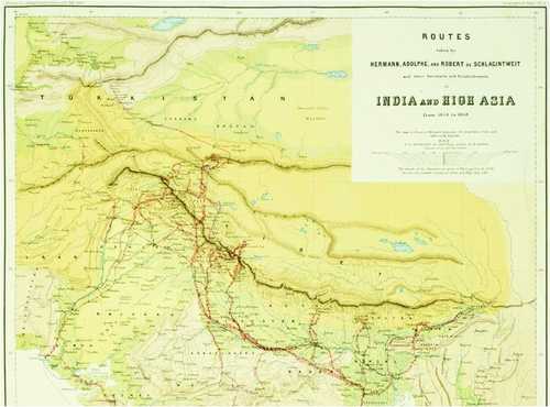
The Schlagintweit Brothers’ Itinerary in India and High Asia
Officially, the Schlagintweit brothers were employed by the East India Company (EIC) to investigate terrestrial magnetism in northern India and the adjacent high mountains, following a proposal by Alexander von Humboldt. This task had been entrusted first to the engineer Charles M. Elliot in 1846, but had been left unfinished following his untimely death in 1852. Elliot had only been able to map the seas and the southern part of the Indian subcontinent. The Schlagintweits were now to cover the missing, larger northern section.
Unofficially, however, the brothers’ expedition apparently was intended to gain more reliable knowledge about the Himalayas and the mountain ranges in the North. This was in line with Alexander von Humboldt’s wishes, which were well known in London.1 Furthermore, the EIC is likely to have recognised the opportunity to learn more about the physical geography of the Himalayas and its foothills as well as the network of passes, routes and trails under the guise of scientific surveys. In any case, the EIC not only supported the Schlagintweit expedition within its own dominion, but also exerted diplomatic pressure on the adjoining states of Kashmir, Nepal and Sikkim to agree to the brother’s research in these countries. Kashmir consented to this, whilst Nepal delayed its consent and Sikkim refused outright. Tibet was presumably not contacted because it generally prohibited entry of foreigners.
The Schlagintweits apparently only learnt of this refusal after their arrival in India (Fig. 12). This meant that the entire southern side of the central Himalayas would remain as inaccessible to them as the Tibetan Plateau to the north. Although Hermann was allowed to visit Kathmandu and the surrounding area in 1857, there was no time left for further studies in the mountains of Nepal. The plan, under which Hermann was to explore the eastern and Adolph the western part of the Himalayas, had to be modified.
First, however, the brothers had to link up with the data collected by Elliott in the South. From Bombay, where they set foot on Indian soil on 26 October 1854, they travelled first across the Deccan to Chennai, visiting the British observatory at Kaladghi along the way. Without studying southern India in detail, they travelled by ship to Kolkata, the administrative headquarters of the EIC, in March 1855. From there, after lengthy negotiations and the selection of the British and Indian assistants who were to accompany them, they set off in different directions. In order to explore as many areas as possible, the brothers, from then on, travelled almost always separately. Robert, who had come along as an assistant and was not so experienced, usually accompanied one of his brothers and operated the camera they had brought along. He was also responsible for packing and looking after the collections of all kinds that the brothers gathered or acquired.
In June 1855, Hermann set off northwards to the British part of Sikkim, which, situated between the independent states of Nepal, Sikkim and Bhutan, seemed to offer the chance to unobtrusively reach the Eastern Himalayas along the borders. The attempt failed due to the vigilance of the Nepalese border officials. Taking a wide detour, he travelled by boat through Bengal via Dhaka and reached the Khasi Hills in November 1855, and from there Assam. From Guwahati, he undertook a foray into Bhutan to the monastery and administrative centre of Taklung Dzong near Kalaktang (now Arunachal Pradesh), where, however, the powerful Lamas prohibited him to continue his journey to Tawang and Tibet. Hermann therefore returned to Tezpur in Assam and henceforth concentrated his interest on exploring the Brahmaputra, which he travelled up by boat as far as Dibrugarh. In February 1856, he came back to Kolkata, again by boat.
1. In an obituary for Alexander von Humboldt, Roderick Murchison, who as President of the Royal Geographical Society had been involved in the negotiations preceding the expedition, clearly stated this fact in 1859.
Adolph and Robert had already set off in March 1855 towards the North-West, travelling up the Ganga Valley on the Great Trunk Road. Their first destination in April was the British station at Nainital in Kumaon, where they completed their ‘establishment’ of assistants and gained their first experiences on the ground. In June, they travelled through the Nanda Devi region to Milum, intending to reach Tibet from there. In the Sutlej region, however, they were stopped by a border guard. Following negotiations with the authorities in Daba, they were finally permitted to proceed to the Sutlej and visit the monasteries of Mangnang and Tholing there. They also passed the ruins of the old capital Tsaparang, though without realising its historical significance. A push across the Sutlej took them almost as far as Gartok before they returned to British territory via the Mana Pass, attempting to climb Ibi Gamin on the way. Adolph subsequently managed, in disguise, to return once more to the forbidden Ngari Khorsum and completed his measurements and observations. During this time, Robert travelled on to Garhwal and visited the glaciers and pilgrimage sites at Badrinath and Kedarnath.
As winter was approaching, the two brothers then headed south. Adolph explored the Nilgiri Mountains and the territories of the Maharaja of Mysore and returned by ship from Chennai to Kolkata in April 1856. Robert, on the other hand, parted company with his brother in Sagar and travelled via Benares back up the Ganga to the North-West.
After being apart for more than a year, all three brothers met up again in Simla in April 1856 and coordinated their plans. As the Eastern Himalayas had been explored as far as possible and negotiations with Nepal had still remained fruitless, Hermann was free to undertake further explorations in the North-West. There, the regions of Ladakh and Baltistan, controlled by the Maharaja of Kashmir, beckoned. Turkestan, further north, appeared accessible, too. The teams were therefore reorganised.
In the summer of 1856, Hermann and Robert – the former visiting Lake Pangong en route – travelled along separate routes to Leh in Ladakh and set up base there. For the time of their absence, they installed an observation post, which was controlled by their ‘native doctor’ Harkishen. From Leh, Hermann visited the Lamaist monastery of Hemis on the Indus, where he was able to acquire important masks from the Cham dance.
From Leh, the two brothers set off for Turkistan via the Saser and Karakoram passes. To avoid being recognized, they veered off the usual caravan route after crossing the Karakoram Pass and made their way across the deserted plateau to the Karakash River on the southern edge of the Kunlun Mountains. Crossing the crest of Kunlun via the Hindutagh Pass, they were able to look down on Khotan in Xinjiang. From there, they returned to Leh via the usual route. The reconnaissance of the Kunlun Mountains and the insight that the Karakoram was a separate range and part of the main Himalayan watershed later earned Hermann the Russian honorary title ‘Sakünlünski’, meaning ‘pioneer of the crossing of the Kunlun’.
During these months, Adolph travelled via Zanskar and Skardu to Baltistan and Gilgit to study and survey the vast glaciated areas of Mustagh and the adjacent glaciers. Subsequently, he visited the mountains of the Astore Valley in the vicinity of the Nanga Parbat. In October 1856, he arrived in Srinagar for another meeting with his brothers. From there, the three Schlagintweits continued on towards the Punjab.
In Rawalpindi, the brothers learnt that Nepal had finally agreed to their visit. Hence Hermann abandoned his further plans and rushed to Nepal via the Great Trunk Road. In February 1857, he arrived at Kathmandu. He stayed there for almost four weeks, but was unable to reach the high mountains. Having returned to Kolkata, Hermann set off on his journey home in April 1857, travelling via Sri Lanka. In May 1857, he embarked for Europe from the port in Galle.
During this time, Robert was busy transporting the last crates with the Schlagintweit collections overland to Surat, from where they were shipped via Mumbai and Galle to Europe. This afforded Robert a brief last stay in Sri Lanka, where he met up with Hermann again.
What Adolph had planned for the spring of 1857 is not recorded. In any case, he must have decided to return to Europe later than his brothers. He visited the geologically significant Salt Range in the Punjab and then turned towards Lahore. From there, however, he did not explore the South-West of the British dominion, as one might have expected in view of the magnetic measurements, but veered off and turned north again. He passed by Leh and crossed the Karakoram and Kunlun ranges towards the oasis cities of the Silk Road. However, he only reached Kashgar in East Turkestan, where, in August 1857, he incidentally arrived when a Kokandi usurper had taken control who opposed against Chinese rule. The unfortunate German traveller was murdered by Wali Khan Tura who got his companions arrested, enslaved or jailed.1 Adolph, as an obituary put it, had become ‘a victim of his zeal’. Two brothers returned to Germany and Adolph found his grave in Kashgar.
They were later on released and returned to British India and told the tales; see about the murder of Adolph Schlagintweit Hermann Kreutzmann (2025).
Introduction
1 work
An official ‘General Register’ (GR) of the drawings and some photographs was published by Hermann Schlagintweit, in 1859, titled ‘Catalogue of Panoramas and Views from India and High Asia’. The GR numbers are essential for precise determination of the motifs. They are included here at the end of each entry. The GR gives dates of recording, which not always seem to be correct.
The first line of the entry gives the original title of the drawing as listed in the GR.
The Northern part of the Lake of Kashmir
DAL LAKE, NORTH-EASTERN PART, SRINAGAR, JAMMU AND KASHMIR
Private Property, Munich (GR 463)
This sheet is the ‘northern’half of a wide panorama Hermann and Adolph Schlagintweit painted simultaneously, back-to-back, during their brief stay at Srinagar. The views of this most famous lake of all India were probably painted for King Friedrich Wilhelm IV of Prussia, whose interest in the lake and the adjacent Shalimar Bagh was certainly known to them. They even possessed (or had photographed?) a small portrait of the princess Nurmahal who perhaps was interpreted as a likeness of the Spontini’s opera heroine.
Nainital & Its Mountains
7 works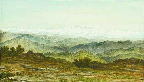
Nainital was the place of Adolph and Robert Schlagintweit’s first personal experience seeing the impressive Himalayan Range. The brothers stayed at the British Station from mid-April to mid-May 1855, exploring the complex geological structure of the Himalayan region. The explanatory sheets belonging to the drawings document Adolph’s scientific ambitions. A prolonged stay on the Chiner [China or Naina peak, 2,615 m] provided a good overview of Nainital and the sequence of peaks resulting in the very first drawing of their Himalayan panoramas.
Station and Lake of Nainital
NAINITAL, UTTARAKHAND
Staatliche Graphische Sammlung Muenchen (41795 Z; GR 414)
While his brothers preferred drawing, Robert was a pioneer of the then rapidly developing photography. This image is based on a photograph by Robert which was later coloured by Hermann who never saw this scenery with his own eyes. There had been a corresponding drawing by Adolph, but Hermann apparently substituted it by Robert’s photograph.
Lake of Nainital with the Spurs to the Plains
VIEW FROM CHINER PEAK, NAINITAL, UTTARAKHAND
Bayerische Staatsbibliothek Muenchen (Schlagintweitiana III.14, fol. 6; GR 415)
This is a view from the southern slope of Chiner Peak, with the summits of Lariya Kanta (2,482 m) and Sher ka Danda (2,398 m) to the left. Adolph apparently was fascinated by the abundant vegetation; he documented oaks to the right and a Rhododendron tree and -bushes in the left-hand foreground.
Himalaya Ranges from Chiner Peak
THE HIMALAYA FROM NAINA PEAK, NAINITAL
The height of the Chiner peak (2,615 m) and its distance from the high mountain ranges allowed Adolph and Robert a splendid first survey of the Western Himalaya. The ‘ChinerPanorama’ was the first to be measured, drawn and published in the Schlagintweits’ Results volume of 1862 (No. 2, profile 3).
Outer Himalaya from Leria Kanta
VIEW TO THE PLAINS FROM LARIYA KANTA, NAINITAL
Alpines Museum Muenchen (GR 418)
The peak of Lariya Kanta (2,482 m) in the west of Nainital presented a good overview over the southern foothills of the Himalaya and the wide plain of the Ganga basin.
The Chiner Summit from Leria Kanta
NAINA PEAK SEEN FROM LARIYA KANTA, UTTARAKHAND
Private Property, Muenchen (GR 419)
The view from the western peak of Lariya Kanta (front) to Sher ka Danda (left) and the Chiner (the massive summit on the right) shows peaks belonging to the same range, but of different geological composition and mineral deposits. Adolph seems to have been intrigued by this puzzle.
Cleavages on the southern Slope of Chiner
NAINA PEAK, NAINITAL, UTTARAKHAND
Bayerische Staatsbibliothek Muenchen (Schlagintweitiana III.14, fol. 11; GR 420)
This seemingly insignificant drawing documents in its upper left quarter, according to the explanatory sheet, cleavages in the rock of Chiner Peak, which were of great geological interest. The foreground is dominated by the oak forest which arose Adolph’s admiration.
The Summit Leria Kanta from Sher ka Daanda
LARIYA KANTA SEEN FROM SHER KA DANDA
Alpines Museum Muenchen (GR 421)
In the final days of his stay at Nainital, Adolph visited again the peaks overlooking the lake to record different geological rock formations and geomorphological features exposed there.
Baltistan & Ladakh
7 works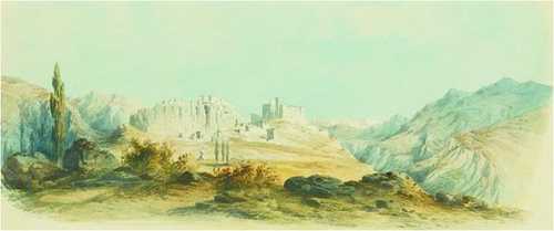
Both regions were dominated by Gulab Singh, the Maharaja of Jammu and Kashmir, since the Treaty of Amritsar in 1846 when the British gave him a ‘carte blanche’ north of the Indus. Nevertheless, British influence made him consent with the Schlagintweit brother’s explorations in his realm.
Tibetan Houses in Leh, in the Northern Part of the Town
HOUSES NEXT TO STAGOPILOG STUPA GATE, LEH, LADAKH
Alpines Museum Muenchen (GR 348)
At Leh the Schlagintweit brothers saw, for the first time, substantial Tibetan-style houses with multiple storeys, small unglazed windows and flat roofs. According to Hermann’s description, Tibetan houses normally had skylights which gave light from above and allowed ventilation during the warm season. Lamayuru Monastery (GR 271)
The Gonpa or monastery of Lama Yuru in Ladak
LAMAYURU MONASTERY, ON THE LEH-KARGIL ROAD, LADAKH
Alpines Museum Muenchen (GR 271)
Lamayuru Gompa is one of the oldest monasteries of Ladakh. Hermann was warmly welcomed by the lamas and entertained with salted butter tea. The discussion focused on the annual precipitation pattern in this region with an extreme arid climate. The monks informed him about many years devoid of any rainfall or snow cover in the valley bottoms. The monks refused to trust his reports about heavy rains in the Khasi Hills, thus ignoring the climatic variations within the Himalayas that were recorded by the Schlagintweit brothers.
Hot Springs below Vaka in Dras
MULBEKH HOT SPRING, ON THE MULBEKH RONG, WAKHA VALLEY, KARGIL, LADAKH
Alpines Museum Muenchen (GR 596)
Hydrothermal phenomena were subjects of special interest for the Schlagintweit brothers who visited several hot springs. On his way from Leh to Kargil Hermann learned, passing through the Wakha or Paskhyum valley, about a hitherto unknown hot spring below Mulbekh monastery. He made a short detour and studied this spring. His sketch catches the enormous rocks at the end of the narrow valley, but shows an abundant oasis vegetation in the desert-like environment.
Gushka Dar, left Side of Chandrabhaga Valley
JUNCTION OF CHANDRA AND BAGHA RIVERS IN GUSHAL, SEEN FROM KARDANG MONASTERY, LAHUL, HIMACHAL PRADESH
Alpines Museum Muenchen (GR 458)
The drawing’s title is misleading, as Adolph never visited the proper Chandrabagha Valley in the Chenab watershed. On his way from Shimla to Baltistan, he took this view from Kardang Monastery, looking back to the point – deep down in the valley – where Chandra and Bhaga join together to form Chandrabagha. He probably was impressed by the symmetrical mountain massif behind Gushal, the sangham. The drawing’s foreground was added by Hermann and blocks the view into the low lying Bhaga Valley at Keylong on the right hand.
The Padum Basin seen from the ancient Moraines of Haptal – Glacier
PADUM IN ZANSKAR, LADAKH
Alpines Museum Muenchen (GR 512)
For his approach from Lahul to Baltistan, Adolph followed the route along the Tsarap and Zanskar rivers. He visited Zanskar’s capital Padum, located in a wide basin, which had been formed by a prehistoric lake. Contrarily to Hermann’s later assumption, Adolph looked northeast towards the Zanskar River.
Valley of the Shayok near Khabulu
THE SHYOK VALLEY NEAR KHAPLU
Alpines Museum Muenchen (GR 527)
Shortly before Adolph reached Skardu he touched the Shyok river, a major tributary of the Indus. Not far away from its confluence with the Indus at Keris (Keres) Khaplu is located, which was a Balti principality only second to Skardu and played a key role in supplying traders on the barren Shyok route to Ladakh and Yarkand.
Indus Valley near Skardo from Gulab Singhs New Fort
OLD FORT SKARDU, BALTISTAN
Alpines Museum Muenchen (GR 540)
Coming from Mustagh pass, Adolph turned towards Skardu arriving there on 1 September 1856. Skardu has been an important centre and bazaar in the Karakoram Mountain range. Skardu is located south of the confluence of the Indus and Shigar rivers. From Skardu Fort, Adolph had an impressive view of the Indus and the wide basin there.
Assam & Khasi Hills
4 works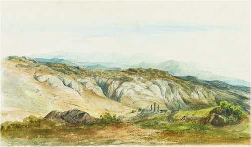
Hermann Schlagintweit pursued the recording of terrestrial magnetism in the North-East of India. During the monsoonal season of 1855, he travelled to one of the oldest British stations: Cherrapunji in the Khasi Hills.
Foot of the Khassia- and Jaintia Hills from the Surma River
KHASI AND JAINTIA HILLS, FROM BENGAL
Staatliche Graphische Sammlung Muenchen (24905 Z)
From Sikkim Hermann travelled to the Khasi Hills in Assam. He started his tour in Siliguri on 15 August 1855 riding on an elephant. Since he was seriously ill and the river valleys were flooded, he continued the journey by boat. Following the Ganga and Surma rivers he reached Sylhet on 22 September. As the present drawing is dated two days earlier, Hermann had captured the scene some miles below Sylhet. The section covers the area from the South over the Bengal plain to the hills. The almost panoramic idyllic view shows the alluvial land with fertile cultivation, lush vegetation and some houses of local farmers. View from Khasi Hills to Jaintia Hills (GR 79)
The Jaintia Ranges, from the West
VIEW FROM KHASI HILLS TO JAINTIA HILLS
Alpines Museum Muenchen (GR 79)
Hermann Schlagintweit captured the Jaintia Hills in October, a time of ideal weather with clear skies and pleasant temperatures. The hills are located further to the East from the Khasi Hills and are part of the sparsely populated Meghalaya plateau. In the foreground of the picturesque landscape shaped by erosion and deeply washed-out gutters is placed a typical Khasi stone monument.
Khassia Stone-Pillars and -Tables at Cherrapunji
KHASI MONOLITHIC MONUMENTS AT CHERRAPUNJI, MEGHALAYA
Alpines Museum Muenchen (GR 259)
In the Khasi Hills, Hermann noted monuments made from erect monolithic stones and slabs, reminding him of European prehistoric megalithic monuments. He drew some near Cherrapunji and took measurements: The highest pillar held nearly six meters. Today these memorial stones and repositories are thought to be connected with the burial of human remains and to reflect the matrilinear clan structure of the Khasi community.
Telescopic View of Giants Peak in Bhutan from Gohatti
BHUTAN PEAK SEEN FROM GUWAHATI
Alpines Museum Muenchen (GR 599)
As Hermann Schlagintweit was doubtful whether he could reach Bhutan and the Himalayan region, he began to study and sketch some of the high snowy peaks in the eastern part of the Himalaya from the Khasi Hills. The group of the Dal-la mountains has two outstanding peaks, which the British termed the ‘Gemini’ (twins). Hermann frequently recorded the term ‘Giant peak’ for the higher one. In Guwahati Hermann used a telescope for his observation of the mountain range.
Trans-Himalaya
8 works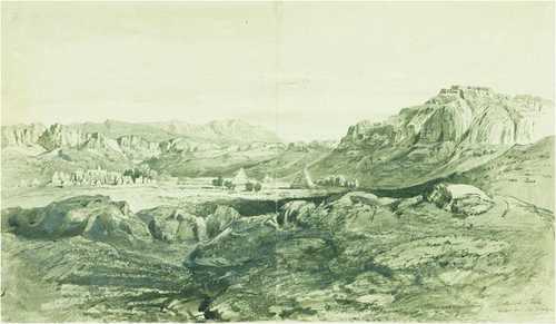
Exploring the Himalayan Mountain range called for inspecting its northern side as well. While its southern slopes were within the realm of the East India Company, political tensions and travel restrictions by the Tibetan rulers barred foreign explorers and traders from entering Tibet. Their only option was to travel in disguise.
The Tibetan Slope of the Himalaya in the Environs of the Niti Ghat
NORTHERN SLOPE OF THE HIMALAYA, ZANDA COUNTY, NGARI PREFECTURE
Private Property, Muenchen (GR 474)
Adolph executed this drawing of the northern slopes of the Himalaya at a time when travel restrictions banned him from proceeding further north. The mountain slopes flanking the old basin of the Sutlej have been carved out by glacio-fluvial erosion guarding the river draining to the right.
The Satlej near Camp Dulla Sumda
SUTLEJ, IN ZANDA COUNTY, NGARI PREFECTURE
Staatliche Graphische Sammlung Muenchen (41848 Z; GR 480)
According to the date, the drawing was done at a campsite where the Gyungul river joined the Sutlej. Adolph remained there for some days after the local authorities had agreed to his presence. He recorded the post-glacial river which has cut its deep bed into older geological formations. Tholing Monastery (GR 493)
View of Toling in the Sutlej Valley
THOLING, TODAY ZANDA, NGARI PREFECTURE
Alpines Museum Muenchen (GR 493)
During his short stay in Ngari Khorsum, Adolph visited Tholing, perhaps the most important Buddhist monastery in Western Tibet and the spiritual centre of the early kingdom of Guge. The monastery was badly damaged during China’s Cultural Revolution, its remains are found on the left bank of the Sutlej. This seems to be the earliest existing drawing of the complex and the first one published by Hermann Schlagintweit in 1859.
Dervasa Sultan Chuskun, at the Junction of the Kissilab and the Shayok
CAMPSITE DARVAZA SULTAN CHUSHKU, ON THE SHYOK
Alpines Museum Muenchen (GR 556)
The Sultan Chhusku (temporary) Campsite is located southeast of the more prominent SaserBrangsa (camp) and part of the section taken during winter on the caravan route from Leh to Yarkand, below the Saser Pass en route to the Karakoram Pass, where one had to cross the Shyok river a second time. The view is taken from the course of a small tributary. Hermann was impressed by the scenery ‘peculiarly desolate, however beautiful in the greatness of its forms’ and published it in 1858 as ‘one of the highest and wildest landscapes of the Karakoram mountains’.
Bullu, Halting-Place on the right Side of Yarkand River
CHADARTASH, CAMP ON THE WAHAB JILGA IN KARAKORAM
Alpines Museum Muenchen (GR 564)
The second halting place or shelter (pulu) beyond the Karakoram Pass en route to Aktagh is Wahab Jilga on the stream of the same name, a tributary in the catchment of the Yarkand River. Next to it was Chadartash, ‘the tent stone’, identified by the two rocks located in the river bed. Hermann described the barren and desolate landscape as a region of emptiness: “The view of this region where we arrived after a hard day’s march from the northern foot of the Karakorum pass, presented a most melancholy and desolate aspect, which, however was soon followed by tracts of still greater barrenness after leaving the valley and approaching the Kuenluen. [….] Numerous remains, the waifs and strays of caravans crossing the heights, skeletons and carcasses of horses, luggage, saddles, fodder for animals of burden and not unfrequently the low temporary tomb of a Mussalman are the way-marks indicating this valley to be the road to Yarkand. As everywhere at great elevations, so also here, the sky shows dark tint, but the reddish veil along the horizon is peculiar to the plateaux separating the chains of the Karakorum and the Kuenluen regions […].”
Vohab–Plateau in Turkistan, second Camp from Karakorum
WAHAB JILGA CAMPSITE ON THE AFFLUENT TO THE YARKAND RIVER
Alpines Museum Muenchen (GR 565)
Vohab Chilgane is a corruption of Wahab Jilga. It was a campsite on the river, called after a small brook. From the plateau over the camp Hermann had a unique view, on the rather flat, desert-like landscape of upper Turkistan to the East. The challenging route afforded to traverse a wide uninhabited environment where the upper valleys appeared to be plateaux-like landscapes.
Sikander Mokam in the Valley of Karakash
RUINS ON THE UPPER KARAKASH RIVER, AKSAI CHIN
Alpines Museum Muenchen (GR 573)
The Leh-Yarkand route is scattered with graves of deceased travellers. In the upper Karakash valley, Hermann was fascinated by a ruin complex called, by his guides, ‘Sikander Mokam’. By the person’s name Hermann was reminded of the ancient Macedonian king’s famous expedition to India.
The upper Part of the Karakash Valley from Sumgal
KARAKASH VALLEY NEAR SUMGAL, AKSAI CHIN
Alpines Museum Muenchen (GR 576)
Sumgal was the name of a camping-ground on the bank of the Karakash River, the last halting place below the ascent to the Hindu Tash Pass of the Kunlun Mountains towards Khotan. The brothers left their companions and luggage at Sumgal and crossed the pass on their own. Buhaniyar Temple (GR 270)
Places of Worship
10 works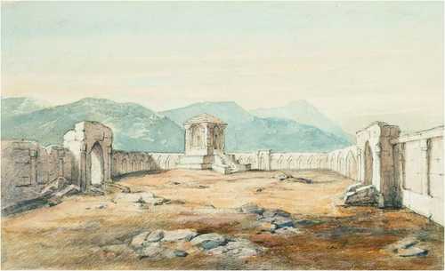
As natural scientists, the Schlagintweit brothers were only remotely interested in the different religious practices they encountered on the Indian subcontinent. Because of their Catholic upbringing they were suspicious towards Hindu and Islamic rituals. The only exception was Buddhism that in its Tibetan Lamaist expression fascinated them.
Nevertheless, the brothers’ interest in water and rivers as important geographical features shaping the landscape and determining by their valleys routes of travel and trade met with Hindu traditional veneration of sources and confluences (sangham) as sacred places.
Ruins of a Hindu Temple above Chakotri in Kashmir
BUHANIYAR TEMPLE RUINS, NOWSHERA, JAMMU AND KASHMIR
Alpines Museum Muenchen (GR 270)
Hermann discovered these remains of an early Hindu temple on the banks of the river Jhelum, some miles above Chakothi and took some measurements. The drawing does not show the real situation with the cell in the middle of the peristyle, but a reconstruction based on sketches.
Temple at Badrinath, over the hot Springs
BADRINATH, UTTARAKHAND
Staatliche Graphische Sammlung Muenchen (41791 Z; GR 266)
Badrinath, with its famous temple dedicated to Lord Shiva built above the salutary mineral springs, is one of the prime Hindu pilgrimage sites. Returning from their excursion to GnariKhorsum via the Mana Pass Adolph and Robert Schlagintweit visited Badrinath, where Robert took a photograph of the temple. His image shows the site before it was rebuilt in the 1870s and was taken from an uncommon oblique position which accentuates the cupola over the sanctuary.
Temple at Kidarnath
KEDARNATH IN THE MANDAKINI VALLEY, UTTARAKHAND
Staatliche Graphische Sammlung Muenchen (41792 Z; GR 267)
From Badrinath, Robert proceeded to Kedarnath, the other important pilgrimage site in Rudraprayag. His prime interest was devoted to the twin glacier at whose mouth the temple dedicated to Lord Shiva had been erected. In addition, he was searching for a direct route to Gangotri which, as he had been told seemed to have been in use 30 years earlier. Unfortunately, the glacier’s course did not allow their passage. Robert took a photograph of the temple, documenting the building and its surroundings before the subsequent growth of the village.
The Gangotri Group from the Nelong Pass
THE GANGOTRI GROUP SEEN FROM THE TAGA LA PASS, UTTARAKHAND
Alpines Museum Muenchen (GR 441)
The Gangotri Group, the headwaters of River Ganga, was an important destination for Adolph. He first saw it on his return from the second trip to Ngari Khorsum from Thaga La Pass, which he called the ‘Nelong Pass’) and sketched the view from the South. The interesting drawing from his own hand shows his manner of sketching and contains notes for future interpretation. Adolph made use of a theodolite to avoid distortion of the scale, as is shown by the graduation at the top.
The Village of Nelong in Gharval
NELONG / NELANG, UTTARAKHAND
Staatliche Graphische Sammlung Muenchen (41789 Z; GR 341)
The passage from Thaga La Pass via the village Nelang on the Jadh Ganga river had been on an important trade route from Tibet to India. The traffic was stopped in 1962 during the Indo-Chinese war, when the area was occupied by China and the village evacuated by the Indian Army. Adolph’s drawing might show an early record of the deserted Nelong village.
Bhaghiratti Valley below Mukba
BHAGIRATHI VALLEY BELOW MUKHBA, NEAR GANGOTRI, UTTARAKHAND
Staatliche Graphische Sammlung Muenchen (41797 Z; GR 439)
This drawing of the uppermost part of River Ganga – perhaps done at Harsil a few miles down from Gangotri – suggests that Adolph visited the famous pilgrimage site. Unfortunately, there are no precise dates, drawings or references for such a visit. Nevertheless, Adolph was fascinated by the pine and cedar forests covering the mountain slopes.
Buddhistic wooden Temple near Simla
TARA DEVI TEMPLE, IN THE VICINITY OF SHIMLA, HIMACHAL PRADESH
Staatliche GraphischeSammlung Muenchen (41803 Z; GR 265)
The temple on a hill top near Shimla is seen in the photograph used by Hermann, which shows the building in its original 18th-century form with much less decoration. It is interesting to learn that Hermann qualified this Shimla temple as ‘Buddhist’. The goddess Tara is venerated by Hindus and Buddhists alike. He identified this temple as a predominant Buddhist sacred place.
Interior of the Buddhistic Temple at Mangnang
RUINED MONASTERY MANGNANG GOMPA, WESTERN TIBET
Staatliche Graphische Sammlung Muenchen (41842 Z; GR 269)
On their way back from Gartok Adolph and his brother Robert visited the Buddhist monastery in Mangnang and its temple. The ceiling of the rather dark and poorly decorated room was supported by wooden beams. From the ceiling hung a remarkable number of prayer flags and thangka. In the background stands the altar decorated with ceremonial objects. A skylight in the roof, scarcely visible in the drawing, supplied proper illumination of the statues. For the print in his ‘Results volume’, Hermann decided to have the room changed considerably.
Interior of the Lama House at Saimonbong in Sikkim
SALAMBONG, WEST OF RANGPO, WEST BENGAL
Alpines Museum Muenchen (GR 262)
Hermann captured this room in a lama’s house above Salambong serving ceremonial purposes with many details. The house was the residence of an influential lama. With help of his political and scientific consultant Chibu Lama, a Bhotiya from Sikkim, Hermann purchased several ceremonial objects for their collections.
Trespon, Village in the Suru Valley
TRESPONE, SOUTHWEST OF KARGIL, LADAKH
Staatliche GraphischeSammlung Muenchen (41824 Z; GR 345)
Islamic institutions were rarely mentioned in the Schlagintweit records, though they were prevalent in India. Near Kargil, in the Muslim-dominated West of Ladakh, Hermann discovered a small mosque which seemed worth a description and illustration. It was a modest rectangular building with a flat roof without a prominent minaret. The front wall was painted with broad red pillars in Indian style. The building was probably an early specimen of one of the Shia mosques in contemporary Trespone. To the right of the mosque Hermann showed ruins of an earlier building which apparently belonged to an earlier Hindu temple.
Housing & Settlements
17 works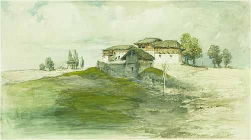
About one tenth of Schlagintweits’ drawings depict rural settlements, hamlet dwellings and technical buildings. Most of them show different types of make-shift buildings rarely conserved until today.
Garro Timber-House in a Settlement North of Goalpara
GOALPARA, ASSAM
Alpines Museum Muenchen (GR 307)
The Garo community is part of the major Tibeto-Burman linguistic group of Assam. They are acknowledged for the fact that land titles are matrilineally transmitted. Settled south of the Brahmaputra most live in the Garo Hills. The situation depicted by Hermann was recorded in Goalpara on the south bank of the Brahmaputra in Assam where he saw this hut – uncommon for Garo architecture – probably on his return from Bhutan to India. The archaic construction must have fascinated him: vertically set, untrimmed logs formed the wall and supported the thick, low reaching roof.
Khassia Houses at Cherra Punji
CHERRAPUNJI; EAST KHASI HILLS, MEGHALAYA
Alpines Museum Muenchen (GR 311)
The drawing combines three forms of construction for humid regions like the Khasi Hills. In fact, Cherrapunji is among the stations with the highest rainfall on Earth. The Khasi form an island of Austro-Asiatic speakers with peculiar adapted building techniques. The left-hand building is constructed on high ground, that on the right on a massive platform of irregular granite boulders, the smaller hut in the middle is set on poles. In the exposed situation of the village, the roofs — made from thick layers of thatch or reed — reach wide down or show a considerable projection.
Khassia Houses and Compound, Morlung
probably MAWPHLANG, W OF SHILLONG, MEGHALAYA
Alpines Museum Muenchen (GR 315)
The house, apparently situated in an isolated place, seems similar to the timber house attributed to the Garo. Interesting is the strong fence protecting the house against intrusions from wild and domestic animals.
Naga Compound, on the upper Noh Dihing
DIYUNG RIVER, NAGALAND
Alpines Museum Muenchen (GR 320)
The Noa Dehing is an affluent of the Brahmaputra in Nagaland. Hermann delegated the visit of this region to his British assistant, Lieutenant Adams, who seems to have participated in the architectural research. Adams’ draft of this Naga farm was elaborated by Hermann himself. The drawing clearly shows the wickerwork closing the intervals between the main posts.
Village Mangeldai, Central Assam
MANGALDAI, DARRANG DISTRICT, ASSAM
Alpines Museum Muenchen (GR 82)
On his way from Guwahati to Bhutan, Hermann passed Mangaldai on the Brahmaputra. Impressed by the frugal and fragile style of the hamlet, he stated: “the houses, built from woven reed with a few posts of bamboo or timber and covered with masses of reed, belong to the simplest buildings one may find …” Hermann’s drawing shows the system of posts and woven filling, with verandas on both sides.
Udelguri Village, near the Bhutan Himalaya
UDALGURI, DARRANG DISTRICT, ASSAM
Alpines Museum Muenchen (GR 84)
Udalguri was a village in the Bhutan Duar with a British Fort to control the Dhansiri valley as an important passage to Bhutan. The domestic buildings were similar to those of Mangaldai, built directly on the swampy soil. The light, resilient construction was well adapted to the occurrence of frequent earthquakes.
Míshmi Houses on Majuli Island
MAJULI, river island in the Brahmaputra, JORHAT DISTRICT, ASSAM
Alpines Museum Muenchen (GR 321)
The Miri (Mishing) are the second largest community and predominant in East Assam, to which the large Majuli Island belongs. Dikshit and Dikshit (2014: 384) stated: “A people of Tibetan stock, the Miris acted as intermediaries between the people of the hills and the plain and worked as a channel of communication … monopolizing much of the trade. The name ‘Miri’, meaning go-between has been derived from their role as intermediaries in the trade between hill communities and the people of the plain.” Majuli is the largest island in the Brahmaputra. “The Miri villages are usually small consisting of a few huts on stilts with walls of split bamboos and sloping thatched roofs.” (p. 385)
Outpost ChongtongChauki, British Sikkim
(CHUNGTONG, NE OFDARJEELING, WEST BENGAL
Staatliche Graphische Sammlung Muenchen (41783 Z; GR 329)
From Darjeeling, Hermann visited this police outpost in the hill station’s vicinity. The description as ‘British Sikkim’ is misleading as Darjeeling belonged to Bengal and not the Kingdom of Sikkim. The building to the left, perhaps the police station, shows half plastered, half woven walls and a veranda below the thatched roof. There are some thatched huts, probably as dwellings for staff members.
Lepcha Houses in the Settlement near the “Junction”, Darjiling
DARJEELING, WEST BENGAL
Staatliche GraphischeSammlung Muenchen (41777 Z; GR 323)
The Lepcha are the principal autochthonous community of Sikkim and the Darjeeling hills. Hermann remarked that their houses were even less solid than those seen in Assam: “In Sikkim one sees only wooden poles, mats and basket-like wickerwork. The floor of the house rests not on the earth, but on a platform supported by poles to allow the rain-water to flow off.”
Bengali Barrack–Houses at Sigauli
SAGAULI/SUGAULI; BIHAR
Alpines Museum Muenchen (GR 298)
Sagauli is the place where in 1815 the British East India Company and the Kingdom of Nepal fixed the future boundaries; a British station with a small garrison controlled the access to the Kathmandu Valley. The regular disposition of the barracks reflects British military architecture, though the construction with walls of woven organic material follows the local tradition adapted to the climate. To the left, the bungalow of the British commander is indicated.
Tollhouse in the Nepal Tarai
RAXAUL, BIHAR, BIRGUNJ, NEPAL
Alpines Museum Muenchen (GR 299)
The Indo-Nepali border at Raxaul-Birgunj was the principal border long before Nepal was connected to roads. It is not clear whether this official building belonged to the East India Company or to the Nepalese government. The levy of customs and road tolls were an important source of income for both sides. The rather solid building was erected on a high platform protecting it against high water levels and threats. The fence seems to be intended against the elephants frequently used in this region.
Subedar’s House and Temple near the Bishnat Bridge, North of Kathmandu
BISHNUMATI RIVER, KATHMANDU
Alpines Museum Muenchen (GR 332)
Most probably this is the Dallu bridge connecting Kathmandu with Swayambunath Stupa; the path leads through intensive rice cultivation. Nowadays this has become an urbanised area of Kathmandu city. This is a rare view of cultivated land near Kathmandu dominated by the presence of social as well as religious authority. The ‘subedar’s house’ might have been the residence of a noble landlord (here the head of an official district).
Street of Native Houses in Fatighar
FATEHGARH; UTTAR PRADESH
Staatliche Graphische Sammlung Muenchen (41751 Z; GR 300)
Fategarh on the Ganga was an important military garrison with a small town. Hermann documented the simple cubical houses made from brick or mud lined along the road. Most small dwellings have gabled roofs; for higher ones, flat roofs seem to have been preferred.
The Goba’s House at Pangkong in Nubra
Watercolour over pencil on paper
Staatliche GraphischeSammlung Muenchen (24911 Z; GR 350) Hermann described this house on the route from Leh to the Karakoram Pass as the dwelling of a great landowner and ‘Goba’, the elected head of the village. It was situated outside the village, a massive main building and two lower wings with flat roofs and a walled compound, quite common architecture of the arid regions north of the main Himalayan ranges and in Tibet.
Kashmiri Houses at Srinagger
SRINAGAR, JAMMU AND KASHMIR
Alpines Museum Muenchen (GR 336)
The hamlet is located on a hilly, dry place. The storage rooms are separate from the main house, in whose basement, in an area with clay walls, livestock was kept. The same construction is used for the kitchen while the upper living quarters and stores are made in wood. The semi-thatched roofs with wooden shingles protect the dwelling from monsoonal rains. Kashmiri houses in Srinagar (GR 336)
Kashmiri Houses, Village Sukne
SOKHNIZ/SUKNIS IN THE MARU WARDWAN VALLEY, KASHMIR
Alpines Museum Muenchen (GR 338)
Hermann saw this remote village east of Srinagar. The modest houses are part of a small hamlet where limited farming and logging is done. At the same time the settlement functions as a stage post on the route between Srinagar and Leh equipped with fodder and fuel for travellers.
Reed Huts at Pashkiun in Kashmir
PASHKYUM VILLAGE, WAKHA VALLEY, SOUTHEAST OF KARGIL, LADAKH
Alpines Museum Muenchen (GR 337)
Hermann mentions such huts as frequent occurrences in the mountains south of Kashmir: “miserable huts, of the most simple construction, rough houses of unhewn timber, or huts built from stone and moss with reed roofs, or completely from reed in a conical form […]”. The huts resemble two types of shelter in a pastoral settlement. The one on the right is reserved for animals, fodder and fuel, while the left one is a sleeping place for shepherds. Both are made of readily available local material.
Bridges
6 works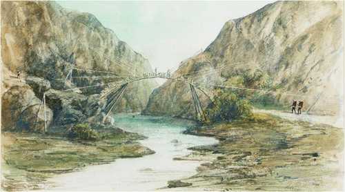
Hermann Schlagintweit was one of the first explorers to document the highly developed bridges in the Himalaya in great detail whose remains and traditions today are estimated as eminent parts of cultural heritage.
Suspension Bridge over the Sutlej at Toling
THOLING, TODAY ZANDA, NGARI PREFECTURE, CHINA
Staatliche Graphische Sammlung Muenchen (41843 Z)
The bridge spanning the Sutlej upstream of Tholing of uncertain age and still existent, combines the traditional cantilever bridge used in the Himalaya with the suspension type: the middle of the bridgeway is suspended from two strong iron chains fixed to the massive bridgeheads. The bridge was revisited by Nain Singh in 1865 who recorded the legend that Alexander the Great was its founder. The bridge must have been reinforced several times. Giuseppe Tucci described it in detail in 1933: “It is indeed a bridge of an entirely new type, at least for this region; instead of being one of the usual cantilever bridges – which themselves are rare enough in these desolate parts of the world – this one is suspended by means of great chains; the links are made by hand and do not show the slightest trace of rust; after so many years, they are as bright as if they had been made yesterday.”1 What Adolph Schlagintweit captured nearly 80 years earlier during his second secret journey into Western Tibet in September 1855 was an important and sturdy bridge that has been maintained all along in excellent shape.
Living Cane-bridge below Cherra [Punji]
West of CHERRAPUNJI, KHASI HILLS, MEGHALAYA
Alpines Museum Muenchen (GR 213) Hermann met ‘living root bridges’ in the Khasi Hills. They were plaited from living aerial roots of gum trees, thus avoiding rotting. The illustrated specimen, localized on the Temshang river, was made from Ficus roots on the river banks only. The suspended part spanning the river was constructed from cane and able to carry one person at a time. As Hermann remarked, only short distances could be spanned by roots alone; longer spans as on the Temshang afforded more sturdy constructions with cane or bamboo. Giuseppe Tucci and Eugenio Ghersi (1935: 155) Bogapani bridge near Mairang (GR 317)
Cane-Bridge over the Bogapani, Khassia Hills
MAIRANG, KHASI HILLS, MEGHALAYA
This spectacular cane bridge is located near Mairang in the Khasi Hills, west of Shillong. Hermann Schlagintweit crossed it on his way back from Cherrapunji to Guwahati. A foot-bridge built as an arc from fresh bamboo, supported by posts near the ends and fixed by ropes.
Bambu-Bridge at Ranigodaun
BAMBOO BRIDGE AT RANIGODAM, ASSAM
Staatliche Graphische Sammlung Muenchen (41740 Z)
According to the drawing’s date, Hermann saw this small bridge at the border of the Khasi Hills, southwest of Guwahati. The bridge is located at Ranigodam where the cultivated land with paddy fields reaches the edge of Rani Forest, here ended regular traffic and the journey had to be continued on foot. The location is on a strategic access route to the forest where the colonial administration maintained a resthouse.
The Erosion of the Satlej at Vangtu Bridge
WANGTU, KINNAUR, HIMACHAL PRADESH
Alpines Museum Muenchen (GR 446)
A much-frequented bridge representing the cantilever type traditional in the Himalayan highlands was built at one of the most impressive locations where a tributary flows into the Sutlej River near Wangtu: From the bridgeheads protruded multiple layers of beams support each other; the gap between both ends is spanned with long beams. The present drawing of the bridge is not correct, as we can learn from comparison with two photographs by Samuel Bourne (1863). The painter ‘translating’ Hermann’s drawing for reproduction forgot the cantilevers on the left and exaggerated the span of the gap. The photograph shows, too, the typical Himalayan masonry with alternating layers of wooden beams and stones which protect constructions from seismic shocks.
Bridge of Boats over the Satlej near Fillur
BRIDGE CROSSING THE SUTLEJ NEXT TO PHILLAUR, PUNJAB)
Alpines Museum Muenchen (GR 181)
Hermann saw this bridge at Phillaur on the Sutlej. Pontoon bridges had advantages over stable bridges when the river was constantly shifting its course or water levels were periodically rising and falling. In the Punjab, the pontoons would be removed during the high-water monsoon period and re-established afterwards. Phillaur was an important river crossing between Jullundur and Ludhiana as part of the Great Trunk Road from Lahore to Calcutta. Thirteen years after this picture was drawn a permanent bridge was constructed on site.
Himalayan Environment
9 works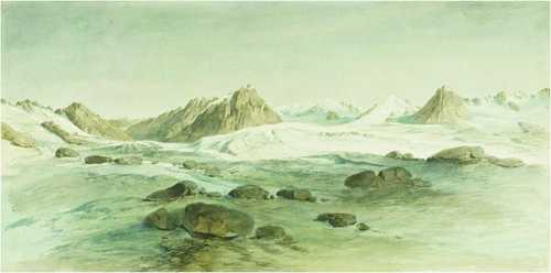
Hermann and Adolph Schlagintweit were trained as state-of-the-art glaciologists in the European Alps. During their travels in Asia, the Schlagintweit brothers restricted themselves mainly to general remarks about the occurrence of glaciers and glaciation. Only in some regions did they find time for more detailed descriptions of glaciers and nival conditions. When Adolph tried to find the main divide of the Karakoram Mountains he came in close contact with its glaciers. The observations and measurements of Adolph Schlagintweit pioneered subsequent global research in glaciology.
Snow Peak “H” from Tonglo
TONGLU PEAK, DARJEELING, WEST BENGAL
Alpines Museum Muenchen (GR 601)
After Hermann got no permission to cross the border to Nepal, he tried to approach the important Himalaya Singalila range on the Darjeeling-Nepal border. On 7 May 1855 he started with his establishment first to the Tonglo, with 3,036 m one of the higher peaks of Singalila ridge. Although hampered by severe rainfall Hermann was enchanted by the colours and contours of the landscape. During a dry spell he captured the snow peak ‘H’ from the Tonglo. This might be one of the highest peaks of the Kanchenjunga Massif in the East.
The Mer de Glace of the Milum Glacier
MILUM GLACIER,UTTARAKHAND
Alpines Museum Muenchen (GR 611)
Adolph Schlagintweit began his scientific studies of the Milum glacier on 16 June 1855. He started at the terminus of the glacier not far away from the habitations in Milum village. The glacier is one of the medium-sized primary glaciers of High Asia with a length of almost eleven (English) miles and five to eight miles width. Hermann Schlagintweit was very astonished to find this glacier not marked on the x map of Kumaon and Garhwal by the British Surveyor General’s Office in 1850.
The Nanda Kath Range and the Pindur Glacier
NANDA KHAT AND PINDARI GLACIER, UTTARAKHAND
Alpines Museum Muenchen (GR 605)
In the summer of 1855 Adolph Schlagintweit and his brother Robert visited Kumaon and Garhwal. Adolph reached the catchment basin of the Pindari Glacier surrounded by magnificent steep rock faces and snow-covered peaks of Nanda Khat (6,611 m). The glacier is situated in the south of Nanda Devi (7,817 m) in the Garhwal-Himalaya with a length of 4.8 km.
The Pindur Glacier in Kamaon
PINDARI GLACIER, UTTARAKHAND
Alpines Museum Muenchen (GR 606)
Adolph followed the route uphill on top of the glacier. This offered him a magnificent view of the glacier and its course. His pencil sketch was taken from the terminus of the glacier in the Pindari Valley.
The Nanda – Devi Group from Shem Kerik
NANDA DEVI NATIONAL PARK, UTTARAKHAND
Staatliche GraphischeSammlung Muenchen (41800 Z; GR 609)
Nanda Devi is located in the centre of the mountain range seen from the Pindari Valley beyond Milum. Bhotiya respect the mountains as the seat of the goddess Nanda Devi who is prominent in many legends and folk tales. After jointly reaching the peak Adolph’s Bhotiya companions, filled with fear of the goddess, sacrificed three goats and sweet cakes to appease Nanda Devi. Adolph was surprised by their sincerity and strong belief in the legends.
Environs of Mana Pass
MANA PASS, ABOVE BADRINATH, UTTARAKHAND
Alpines Museum Muenchen (GR 619)
After Adolph and his brother Robert got no permission to cross the border to Tibet, some days later Adolph made another attempt to reach the mountain range between the Sutlej and the Indus watersheds. He left his campsite at the northern foot of the Mana Pass where he captured the environments leading to Tibet. In full disguise he reached the Voko La Pass and he clandestinely could continue his measurements and observations, taking the desired bearings. The success of his journey gave Adolph real pleasure.
The Pantangsa Glacier in Nubra
NUBRA, LADAKH
Staatliche Graphische Sammlung Muenchen (41838 Z)
On their way to Yarkand, Hermann and Robert Schlagintweit set off from Changlung on 31 July 31 1856. The path crossed the pass, after which they reached the bottom of the Nubra River valley. The next halting-place in the valley was Pangtangsa. The whole upper part of the Pangtangsa depression was filled with firn deposits, a glacier extended down to the bottom of the valley and provided an interesting perspective.
The Mustak Pass bearing North
MUZTAGH PASS, BALTISTAN
Alpines Museum Muenchen (GR 635)
The Western Muztagh Pass (5,370 m) was the hub of Adolph’s most favoured glacier ensemble combining the highest Karakoram peaks such as K2 (8,611 m) and offering a challenging traverse of the mountain barrier from Skardu and Askole in Baltistan to the Sarpo Lago Glacier and Yarkand in Xinjiang. Impressed by its sheer beauty he realised its physical and logistical obstacles. They would make it impossible for pack animals and trade caravans to cross, which preferred the established eastern Leh-Yarkand route crossing five passes over 5,000 metres altitude. Adolph walked five days along the moraine of the glacier to observe and record the glacier movement and its physical properties. He was fascinated by the mesmerising panorama, high peaks separated by glaciated valleys.
Ste – Ste Glacier between Brahaldo and Shigar
SKORO LA GLACIER, BRALDU, SHIGAR
Alpines Museum Muenchen (GR 641)
Returning from the Muztagh region southwards, Adolph used a direct route from Askole close to the Braldu river on his way to Shigar, crossing the Skoro La pass. The coloured sketch of the Ste Ste glacier – probably called so after the village Testay at its lower northern end – is dated to the very day he camped at the Skoro La (29 August). Adolph captured the glacier in its former extent which is nowadays called Skoro La Gans. Skoro La glacier (GR 641)
Himalayan Rivers
8 works
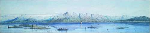
Brahmaputra from Ogri Hill, Tezpur
UPPER BRAHMAPUTRA NEAR TEZPUR, ASSAM
Alpines Museum Muenchen (GR 155)
Hermann’s impressive panorama is taken from a hill overlooking the river bank. The Brahmaputra is sweeping along in a bed of enormous width, having cut its course into the floodplain. The braided river contains smaller and large islands (char) that are wetlands in a dynamic state of growth and decay. The bigger ones feature vegetation such as shrubs, canes and jute. The sky is filled with clouds, thus indicating the rainy season during the winter monsoon. Brahmaputra near Tezpur (section of GR 155)
View of the Brahmaputra, near the southern end of the Moling Hills
Not identified; UPPER BRAHMAPUTRA, ASSAM
Alpines Museum Muenchen (GR 161)
Hermann’s sketch shows the Brahmaputra occupied in its centre by a granite rock. Large sandbanks are deposited above the rock and although changing with every high-water season they are covered with cane jungle. Hermann stated the general height of the water in the rains, which is marked on the rock by trees, which form a well-defined line immediately above it. The outlines of the sand in the foreground sufficiently indicate the erosive force of the river.
Mouth of the Tista, near the Village of Sharpur
TEESTA, NEAR CHILMARI, RANGPUR DISTRICT
Alpines Museum Muenchen (GR 164)
One of the major tributaries of the Brahmaputra is the Teesta which originates in the Eastern Himalayas. Flowing to the South it cut a deeply incised gorge through the hills east of Darjeeling. Hermann Schlagintweit shows the mouth of the Teesta River where it flows into the Brahmaputra River near Chilmari in Bangladesh’s Rangpur Division. After leaving the steep mountain gorges the ephemeral river becomes widely braided close to its sangham with the Jamna (local name of Brahmaputra). These confluences are prone to regular flooding and episodic highwater levels.
Granitic Hills near the Kulong River, Naugong District
KALANG RIVER, NAGAON, ASSAM
Alpines Museum Muenchen (GR 154)
Kalang River has been a secondary tributary of the Brahmaputra. It flows in a former bed of the meandering Brahmaputra stream and diverts from the present river close to Tezpur and re-enters the Brahmaputra twenty kilometres east of Guwahati. Here Hermann Schlagintweit got stuck as his steamer ran into a sandbank, he took the opportunity to observe the granite hills on the banks of the Kalang river and captured the landscape in watercolour. From here he returned to Guwahati by canoe.
Village Bishnath with burning Jangl in the distance
BISHNATH GHAT
Staatliche GraphischeSammlung Muenchen (41736 Z; GR 158)
In Bishnath (Vishwanath) about 42 km upstream from Tezpur Hermann Schlagintweit captured on paper the exciting sight of a burning forest (jangal). The smoke from the fire was visible from far away. Hermann was told that the villagers slash and burn the shrubs on their grazing grounds and fields as swidden agriculture is a common practice in the Northeast. Bishnath Ghat has been an important station for river traffic, control posts and the trading of tea from nearby plantations.
The Ganges opposite Bagatchi, Central Bengal
GANGA NEAR GHULIYAN, WEST BENGAL
Alpines Museum Muenchen (GR 171)
Travelling from Calcutta to Darjeeling Hermann used the postal service (palki dak); the Ganga had to be crossed by ferry on his way from Berhampur to Malda. It was his first encounter with the sacred river. The view from the eastern bank shows low water level in the pre-monsoon and pre-glacier and snow melting season with an island that had emerged between two branches of the river. A striking element is the abundant white sand in the riverbed. Hermann made a remark on the colour and the quality of that quartz sand, which testified the long fluvial transport of suspended matter from the High Himalayan glaciers. Due to the slow flow velocity, the river could no longer hold the sediments and deposited them in the riverbed.
View of the Ganges near Fatigarh
FATEHGARH, UTTAR PRADESH
From Calcutta Adolph and Robert Schlagintweit travelled westward following the Ganga upstream from Allahabad to Bareilly via the garrison town Fategarh, where they reached during the hot pre-monsoon season. Here their interest was focused on the north Indian alluvial plain in which the Ganga took a prominent role as a river and a traffic line. In Fatehgarh Hermann also captured a village street in a watercolour.
Plain of the Ganges between Fatigarh and Kaladungi
GANGA, UTTAR PRADESH
Adolph’s watercolour shows the typical characteristics of an ephemeral river that has left the steep mountains and releases the load of suspended matter in the plain mountain rim. The Ganga flowing through the hills and plains of the United Provinces (Uttar Pradesh) is a prime example for this phenomenon. The landscape is shaped by alluvial deposits from the Ganga catchment area, transported from the High Himalaya by fluvial and glacial movement bringing fertile soil to the lowlands during high flow periods. 8. Select bibliography Bhatt, Uma and Shekhar Pathak. 2006. Asia ki Peeth Per: Pundit Nain Singh Rawat. Jeewan, Anweshan Tatha Lekhan (Life, explorations and writings of Pundit Nain Singh Rawat). Naini Tal: Pahar, 636 pp Brescius, Moritz von. 2018. German science in the age of empire. Enterprise, opportunity and the Schlagintweit brothers. Cambridge: Cambridge University Press, 414 pp Brescius, Moritz von, Friederike Kaiser and Stephanie Kleidt, eds. 2015. Über den Himalaya – Die Expedition der Brüder Schlagintweit nach Indien und Zentralasien 1854 bis 1858. Köln, Weimar, Wien: Böhlau-Verlag, 388 pp Dikshit, Kamal R. and Jutta K. Dikshit. 2014. North-East India. Land, people and economy. Dordrecht: Springer, 800 pp Driver, Felix. 2015. Intermediaries and the archive of exploration. In Indigenous intermediaries. New perspectives on exploration archives, eds. Shino Konishi, Maria Nugent and Tiffany Shellam, 11-29. Acton: Australian National University Press Driver, Felix. 2018. Face to face with Nain Singh. The Schlagintweit Collections and their uses. In Naturalists in the field. Collecting, recording and preserving the natural world from the fifteenth to the twenty-first century, ed. Arthur MacGregor, 441-469. Leiden: Brill Forsyth, Thomas Douglas 1875. Report on a mission to Yarkund in 1873, under command of Sir T. D. Forsyth, K.C.S.I., C.B., Bengal Civil Service with historical and geographical information regarding the possessions of the Ameer of Yarkund. Calcutta: Foreign Department Press, 573 pp Hedin, Sven Anders. 1898. Through Asia. London: Methuen, 663 pp Hedin, Sven Anders. 1913. Trans-Himalaya. Discoveries and Adventures in Tibet, Vol. III: London, pp Jones, Lowri Madeleine. 2010. Local knowledge & indigenous agency in the history of exploration: studies from the Royal Geographical Society-IBG collections. London: Royal Holloway University of London, 248 pp Kreutzmann, Hermann. 2015. Pamirian crossroads. Kirghiz and Wakhi of High Asia. Wiesbaden: Harrassowitz, 559 pp Kreutzmann, Hermann. 2017. Wakhan quadrangle. Exploration and espionage during and after the Great Game. Wiesbaden: Harrassowitz, 282 pp Kreutzmann, Hermann. 2025. On the road to Kashgar. Murder and commemoration of Adolph Schlagintweit. Iran and the Caucasus 29: 200-223 Mason, Kenneth. 1923. Kishen Singh and the Indian explorers. The Geographical Journal 62 (6): 429-440 Moorcroft, William and George Trebeck. 1841. Travels in the Himalayan Provinces of Hindustan and the Panjab, in Ladakh and Kashmir; Peshawar, Kabul, Kunduz and Bokhara; from 1819-1825, 2 Vols. London: John Murray, 459 & 508 pp Montgomerie, Thomas George. 1868. Report of a route-survey made by Pundit *_, from Nepal to Lhasa, and thence through the upper valley of the Brahmaputra to its source. Journal of the Royal Geographical Society 38: 129-219 Murchison, Roderick Impey. 1859. Address to the Royal Geographical Society of London. The Journal of the Royal Geographical Society of London 29: cii-ccxxiv Pangtey, Surendra Singh. 2017. Saga of a native explorer. Pundit Nain Singh C.I.E. Exploration in Trans-Himalayan forbidden land of Tibet and Central Asia during 1865-74. Dehradun: Johar Shauka Varishta – Nagarik Sangathan, 242 pp Pathak, Shekhar. 2017. Pundit Nain Singh Rawat. Explorer extraordinaire. Himalayan Journal 72: 13 Pathak, Shekher. 2023 (2009). Punditon ka Pundit. New Delhi. National Book Trust of India, 195 pp Raj, Kapil. 2007. Relocating modern science. Circulation and construction of knowledge in South Asia and Europe, 1650-1900. Basingstoke: Palgrave Macmillan, 285 pp Schlagintweit, Hermann, Adolphe and Robert de. 1861-1866. Results of a scientific mission to India and High Asia undertaken between the years mdcccliv. and mdccclviii., by order of the court of directors of the Honourable East India Company, 4 Vols.& Atlas. Leipzig: Brockhaus, 494 & 293 & 293 & 586 & 64 pp Schlagintweit, Hermann and Robert Schlagintweit. 1859. Official reports on the last journeys and the death of Adolphe Schlagintweit in Turkistán. Berlin: A. W. Schade, 15 pp Schlagintweit-Sakünlünski, Hermann von. 1869-1880. Reisen in Indien und Hochasien. Eine Darstellung der Landschaft, der Cultur und Sitten der Bewohner, in Verbindung mit klimatischen und geologischen Verhältnissen. Basirt auf die Resultate der wissenschaftlichen Mission von Hermann, Adolph und Robert von Schlagintweit ausgeführt in den Jahren 1854 – 1858. Volume 1: Indien. Jena: H. Costenoble, 1869; Volume 2: Hochasien. I: Der Himalaya von Bhután bis Kaschmir. 1871; Volume 3: Hochasien. II: Tibet, zwischen Himalaya- und der Karakorum-Kette. 1872; Volume 4: Hochasien. III: Ost-Turkistan und Umgebung. Nebst wiss. Zusammenstellungen über die Höhengebiete und über die thermischenVerhältnisse. 1880 Stewart, Jules. 2006. Spying for the Raj: The Pundits and the mapping of the Himalaya. London: Sutton Publishers, 233 pp Tolia, R. S. 1992. Nain Singh Rawat. A teacher, trainer and writer – along with mirror of latitudes. In Saga of native explorers, ed. Surendra Singh Pangtey, 221-240. Lucknow: Johar Shauka Varishta – Nagarik Sangathan Trotter, Henry. 1875. Account of the survey operations in connection with the mission to Yarkand and Kashgar in 1873-74. Calcutta: Foreign Department Press, 165 pp Trotter, Henry. 1877. Account of the Pundit’s journey in Great Tibet from Leh in Ladákh to Lhása, and of his return to India viâ Assam. Journal of the Royal Geographical Society of London 47: 86-136 Tucci, Giuseppe and Eugenio Ghersi. 1935. Secrets of Tibet. Being a chronicle of the Tucci scientific expedition to Western Tibet (1933). London: Blackie & Son, 210 pp Waller, Derek John. 1990. The Pundits: British exploration of Tibet and Central Asia. Lexington: University of Kentucky Press, 348 pp 9. Credits and Contributors – Credits The organisers are grateful for the Alpines Museum Muenchen and the Staatliche GraphischeSammlung Muenchen for their generosity and support in planning and implementing this exhibition. In addition, we are grateful to the Bayerische Staatsbibliothek Muenchen; PAHAR; and Private Collections. Financial support is acknowledged from Free University of Berlin and the Ernst-Reuter-Gesellschaft in Berlin, as well as contributions from Reinhold Neven Du Mont, Iva Schlagintweit-Peyron, Anja Schlagintweit-Melzer and Jorge Lüders. Kaya Schlagintweit represented the Schlagintweit heirs and was highly supportive during the preparation of this exhibition. Johannes Erichsen, former Director of the Bavarian Palace Administration, Munich Stephanie Kleidt, main curator of the Schlagintweit exhibition in Munich 2015-2016 Hermann Kreutzmann, Professor Emeritus of Human Geography, Freie Universitaet Berlin Shekhar Pathak, former Professor of History, Kumaon University, Nainital and Managing Trustee, PAHAR Foundation
Presented in Partnership With
Select Bibliography
8. Select bibliography
Bhatt, Uma and Shekhar Pathak. 2006. Asia ki Peeth Per: Pundit Nain Singh Rawat. Jeewan, Anweshan Tatha Lekhan (Life, explorations and writings of Pundit Nain Singh Rawat). Naini Tal: Pahar, 636 pp
Brescius, Moritz von. 2018. German science in the age of empire. Enterprise, opportunity and the Schlagintweit brothers. Cambridge: Cambridge University Press, 414 pp
Brescius, Moritz von, Friederike Kaiser and Stephanie Kleidt, eds. 2015. Über den Himalaya – Die Expedition der Brüder Schlagintweit nach Indien und Zentralasien 1854 bis 1858. Köln, Weimar, Wien: Böhlau-Verlag, 388 pp
Dikshit, Kamal R. and Jutta K. Dikshit. 2014. North-East India. Land, people and economy. Dordrecht: Springer, 800 pp
Driver, Felix. 2015. Intermediaries and the archive of exploration. In Indigenous intermediaries. New perspectives on exploration archives, eds. Shino Konishi, Maria Nugent and Tiffany Shellam, 11-29. Acton: Australian National University Press
Driver, Felix. 2018. Face to face with Nain Singh. The Schlagintweit Collections and their uses. In Naturalists in the field. Collecting, recording and preserving the natural world from the fifteenth to the twenty-first century, ed. Arthur MacGregor, 441-469. Leiden: Brill
Forsyth, Thomas Douglas 1875. Report on a mission to Yarkund in 1873, under command of Sir T. D. Forsyth, K.C.S.I., C.B., Bengal Civil Service with historical and geographical information regarding the possessions of the Ameer of Yarkund. Calcutta: Foreign Department Press, 573 pp
Hedin, Sven Anders. 1898. Through Asia. London: Methuen, 663 pp
Hedin, Sven Anders. 1913. Trans-Himalaya. Discoveries and Adventures in Tibet, Vol. III: London, pp
Jones, Lowri Madeleine. 2010. Local knowledge & indigenous agency in the history of exploration: studies from the Royal Geographical Society-IBG collections. London: Royal Holloway University of London, 248 pp
Kreutzmann, Hermann. 2015. Pamirian crossroads. Kirghiz and Wakhi of High Asia. Wiesbaden: Harrassowitz, 559 pp
Kreutzmann, Hermann. 2017. Wakhan quadrangle. Exploration and espionage during and after the Great Game. Wiesbaden: Harrassowitz, 282 pp
Kreutzmann, Hermann. 2025. On the road to Kashgar. Murder and commemoration of Adolph Schlagintweit. Iran and the Caucasus 29: 200-223
Mason, Kenneth. 1923. Kishen Singh and the Indian explorers. The Geographical Journal 62 (6): 429-440
Moorcroft, William and George Trebeck. 1841. Travels in the Himalayan Provinces of Hindustan and the Panjab, in Ladakh and Kashmir; Peshawar, Kabul, Kunduz and Bokhara; from 1819-1825, 2 Vols. London: John Murray, 459 & 508 pp
Montgomerie, Thomas George. 1868. Report of a route-survey made by Pundit *_, from Nepal to Lhasa, and thence through the upper valley of the Brahmaputra to its source. Journal of the Royal Geographical Society 38: 129-219
Murchison, Roderick Impey. 1859. Address to the Royal Geographical Society of London. The Journal of the Royal Geographical Society of London 29: cii-ccxxiv
Pangtey, Surendra Singh. 2017. Saga of a native explorer. Pundit Nain Singh C.I.E. Exploration in Trans-Himalayan forbidden land of Tibet and Central Asia during 1865-74. Dehradun: Johar Shauka Varishta – Nagarik Sangathan, 242 pp
Pathak, Shekhar. 2017. Pundit Nain Singh Rawat. Explorer extraordinaire. Himalayan Journal 72: 13
Pathak, Shekher. 2023 (2009). Punditon ka Pundit. New Delhi. National Book Trust of India, 195 pp
Raj, Kapil. 2007. Relocating modern science. Circulation and construction of knowledge in South Asia and Europe, 1650-1900. Basingstoke: Palgrave Macmillan, 285 pp
Schlagintweit, Hermann, Adolphe and Robert de. 1861-1866. Results of a scientific mission to India and High Asia undertaken between the years mdcccliv. and mdccclviii., by order of the court of directors of the Honourable East India Company, 4 Vols.& Atlas. Leipzig: Brockhaus, 494 & 293 & 293 & 586 & 64 pp
Schlagintweit, Hermann and Robert Schlagintweit. 1859. Official reports on the last journeys and the death of Adolphe Schlagintweit in Turkistán. Berlin: A. W. Schade, 15 pp
Schlagintweit-Sakünlünski, Hermann von. 1869-1880. Reisen in Indien und Hochasien. Eine Darstellung der Landschaft, der Cultur und Sitten der Bewohner, in Verbindung mit klimatischen und geologischen Verhältnissen. Basirt auf die Resultate der wissenschaftlichen Mission von Hermann, Adolph und Robert von Schlagintweit ausgeführt in den Jahren 1854 – 1858. Volume 1: Indien. Jena: H. Costenoble, 1869; Volume 2: Hochasien. I: Der Himalaya von Bhután bis Kaschmir. 1871; Volume 3: Hochasien. II: Tibet, zwischen Himalaya- und der Karakorum-Kette. 1872; Volume 4: Hochasien. III: Ost-Turkistan und Umgebung. Nebst wiss. Zusammenstellungen über die Höhengebiete und über die thermischenVerhältnisse. 1880
Stewart, Jules. 2006. Spying for the Raj: The Pundits and the mapping of the Himalaya. London: Sutton Publishers, 233 pp
Tolia, R. S. 1992. Nain Singh Rawat. A teacher, trainer and writer – along with mirror of latitudes. In Saga of native explorers, ed. Surendra Singh Pangtey, 221-240. Lucknow: Johar Shauka Varishta – Nagarik Sangathan
Trotter, Henry. 1875. Account of the survey operations in connection with the mission to Yarkand and Kashgar in 1873-74. Calcutta: Foreign Department Press, 165 pp
Trotter, Henry. 1877. Account of the Pundit’s journey in Great Tibet from Leh in Ladákh to Lhása, and of his return to India viâ Assam. Journal of the Royal Geographical Society of London 47: 86-136
Tucci, Giuseppe and Eugenio Ghersi. 1935. Secrets of Tibet. Being a chronicle of the Tucci scientific expedition to Western Tibet (1933). London: Blackie & Son, 210 pp
Waller, Derek John. 1990. The Pundits: British exploration of Tibet and Central Asia. Lexington: University of Kentucky Press, 348 pp
9. Credits and Contributors
– Credits
The organisers are grateful for the Alpines Museum Muenchen and the Staatliche GraphischeSammlung Muenchen for their generosity and support in planning and implementing this exhibition.
In addition, we are grateful to the Bayerische Staatsbibliothek Muenchen; PAHAR; and Private Collections. Financial support is acknowledged from Free University of Berlin and the Ernst-Reuter-Gesellschaft in Berlin, as well as contributions from Reinhold Neven Du Mont, Iva Schlagintweit-Peyron, Anja Schlagintweit-Melzer and Jorge Lüders. Kaya Schlagintweit represented the Schlagintweit heirs and was highly supportive during the preparation of this exhibition.
Johannes Erichsen, former Director of the Bavarian Palace Administration, Munich
Stephanie Kleidt, main curator of the Schlagintweit exhibition in Munich 2015-2016
Hermann Kreutzmann, Professor Emeritus of Human Geography, Freie Universitaet Berlin
Shekhar Pathak, former Professor of History, Kumaon University, Nainital and Managing Trustee, PAHAR Foundation